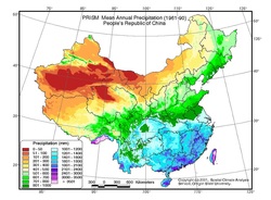
Created by the Himalayas, the Gobi Desert has a large effect on China. And the spreading desertification is will make that effect larger each year unless people continue to stand up and do something about it! Speaking of Climate, what factors determine an area's climate, and how does that affect China's population? And where do different ethnic groups live in this vastly varied landscape? This wraps up our primary focus on geography, and next week is the beginning of our study of Ancient China!
Mountains & Rivers
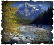
China's natural features had a powerful effect on the development of its early civilization and its history, and they continue to affect us today! To better understand China in detail, we will first take a broad look at the effect of mountains and rivers on people in general, focusing specifically on the Himalayas, the Tibetan plateau, the great Yellow and Yangtze Rivers and the Three Gorges Dam.
SS Foundations
The 6 Themes of Social Studies are the greatest tool students will have this year to help organize their thinking! It is very important that they know these themes backward & forward, as we will soon enter a study of 4,000 years of Chinese history! Although we have spent most of the first quarter on Geography, the other 5 will be just as important in our analysis of Chinese history. Students will be able to take the skills the build this year and use them to organize and analyze their S.S. classes in the future as well!
Shanghai!
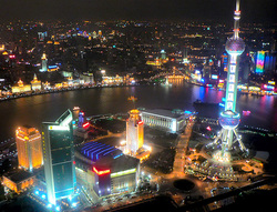
After reviewing for and taking the test, we began our study of our home, Shanghai! In getting to know where we live, we'll be learning the political geography of Shanghai's 16 districts, comparing and contrasting Pudong and Puxi and getting to know what some of the other districts are most well known for.
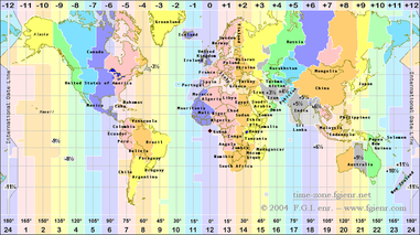
Political Geography of China & Time Zones
After concluding our in-class presentations of individual provinces, we studied a large view of China, discussing what makes each of its 4 types of zones (Provinces, SARs, Autonomous Regions & Municipalities) different and unique.
I've attached the PPT of Time Zone Maps we looked at in class for your own enjoyment; it may help to have a color copy of the complicated world time zones to help with our in-class exercise as well.
Want to know what time it is anywhere in the world? Check it out! http://www.timezonecheck.com/
Here is a great site that will allow you to explore some interesting questions about time zones: http://www.bbc.co.uk/news/world-12849630 - What time is it in space? Antarctica? How does China's 1 time zone affect people? Click & Find out!
Provinces of China
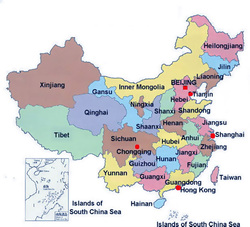
You will need to know where each of these provinces are located as well as what their capitals are. Start memorizing! :) - I've attached some good study tools in the PowerPoint below, including maps of China, the world, and Shanghai's districts; you will see those same blank maps on your mid-term!
Remember, for mid-terms you must also know the capitals! I've also attached the "Chinese Province Table," which gives each province name and its capital, as well as some other interesting information (i.e. population, area) that you don't need to know.
If you would like to use a great online game to practice your provinces, go to: http://www.lizardpoint.com/fun/geoquiz/chinaquiz.html -- You CAN do it - Enjoy! :)
P.S. A different quiz on the same website will help you practice your continents & oceans!
For a puzzling province experience: http://www.yourchildlearns.com/mappuzzle/China-puzzle.html - see if you can beat the student record time of 57 seconds, or Mr. L's record time of 54 seconds! (On Hard Difficulty)
To practice your capitals, cut & paste this link: http://www.sporcle.com/games/swill731/china_province_capitals
Another site you might consider, that only allows you to practice 15 of the capitals, but gives you more background information:
http://www.funtrivia.com/newflash/trivia.cfm?qid=133833
| china_maps_-_provinces__fill_ins.ppt |
| chinese_province_table.doc |
Student Council Elections & Province Presentations
We will briefly step away from Map Skills to focus on Student Council (Elections Monday!). What is government? What kind of qualities should we look for in a good leader? And what does that look like at SMIC?
Our Province Project Presentations begin in class on Monday as well. Having done the research outside of class, students will benefit from each others' hard work and well-earned expertise on different provinces through these presentations.
Our Province Project Presentations begin in class on Monday as well. Having done the research outside of class, students will benefit from each others' hard work and well-earned expertise on different provinces through these presentations.
Latitude & Longitude
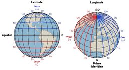
Having created our own thematic maps of the classroom and done some group work with the main map components, we'll be spending the majority of this week on learning and understanding the grid - latitude and longitude lines and coordinates are essential to finding your way around a map!
Pirate Latitude Game: http://media.abcya.com/content/latitude_and_longitude_practice/latitude_and_longitude_practice.swf
Pirate Latitude Game: http://media.abcya.com/content/latitude_and_longitude_practice/latitude_and_longitude_practice.swf
Kicking off the First Week of S.S. with Map Skills!
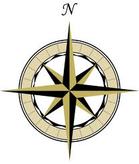
Beginning with the Cardinal Directions to get our bearings, we're moving through the essentials of mapmaking, including types of maps (physical, political and thematic) as well as the five main map components (Title, Grid, Compass Rose, Key/Legend & Scale).
